Never Bet Against America — Warren Buffett.
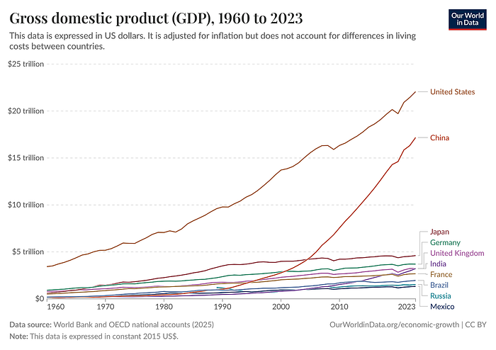
The US is the richest country on Earth.
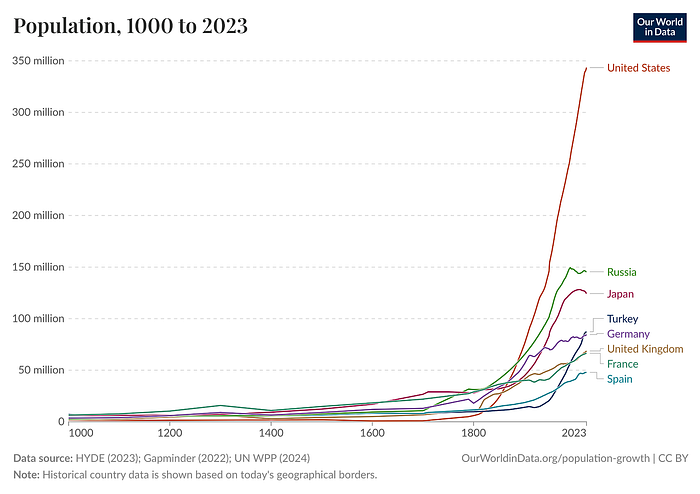
This is due to two reasons. First, the US systematically attracted more immigrants than any other developed country:
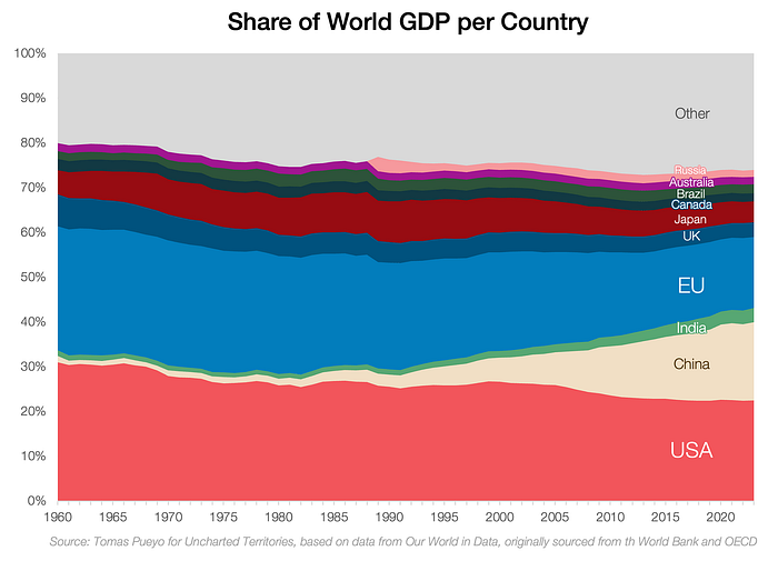
Second, its GDP per capita is the highest in the world for big countries. It passed all other empires sometime in the late 1800s:
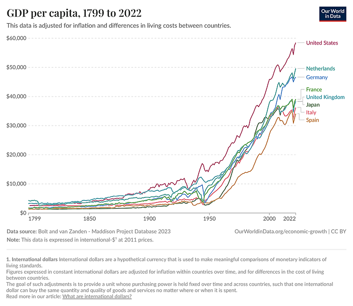
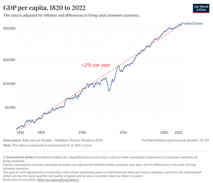
In fact, the US has followed an uncanny trend of nearly 2% growth in GDP per capita for over two centuries:
Why is the US so rich?
Some believe it's due to factors like democracy, the rule of law, the US dollar, its strong military, entrepreneurial culture…
But what if these factors are threatened, as many believe they are now? Will the US then keep growing? Or will it fall due to mismanagement? Is China going to surpass it?
Fortunately for the US, it has the best geography in the world. This is not changing anytime soon, so its power and growth will likely continue in the coming decades.
Can you tell how geography makes the US so powerful?
1. Size

The US is the 4th largest country by surface area. It spans an entire continent, reaches two oceans, and is big enough to be a geographic heavyweight in the world.
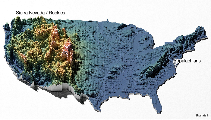
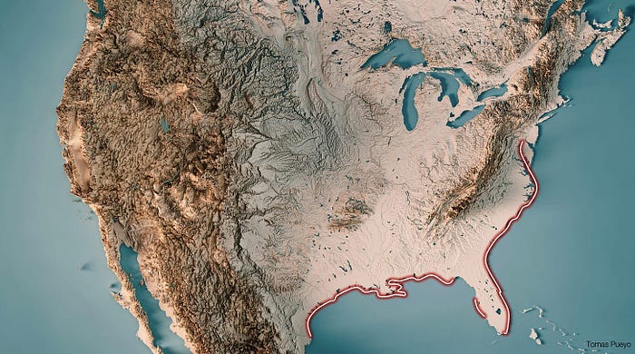
China, Russia, and Canada are bigger. But as we're going to see, Canada is directly neutralized, and China and Russia indirectly. Much of Canada and Russia are unproductive, and the US has a series of advantages that China could only dream of. Just two maps are enough to highlight this luck. The first one explains its impregnability:
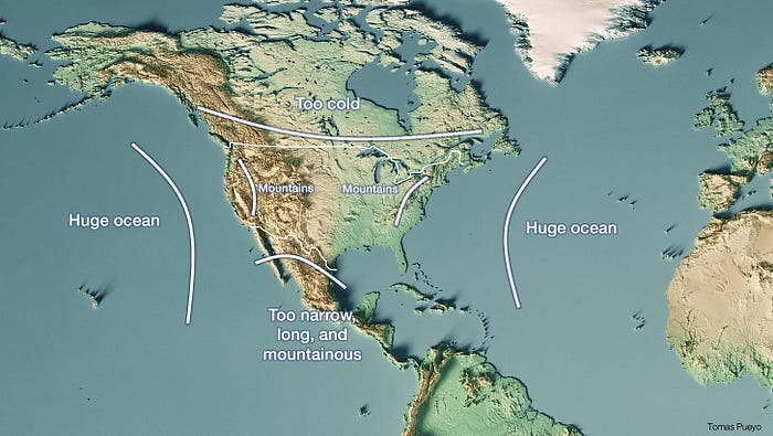
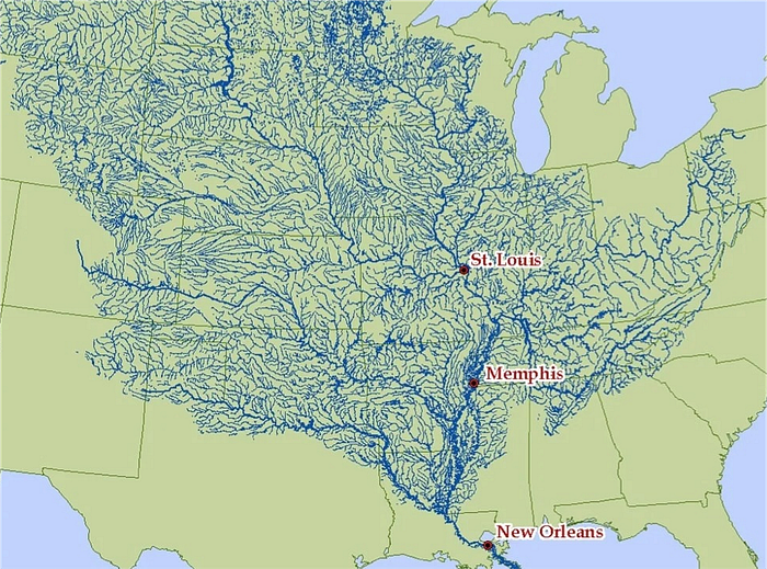
The second map explains the US's wealth.
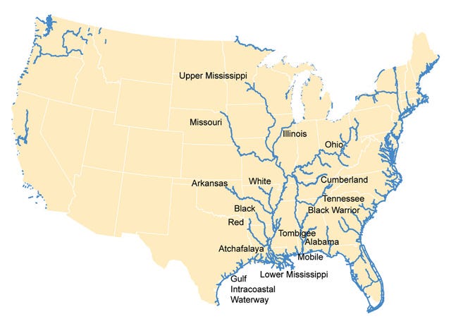
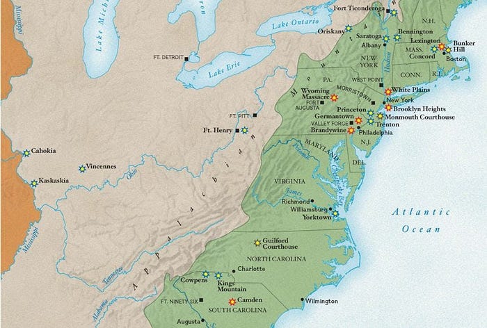
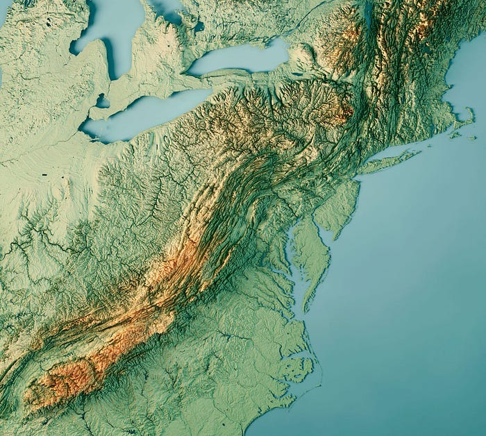
The Crown Jewel of the Mississippi
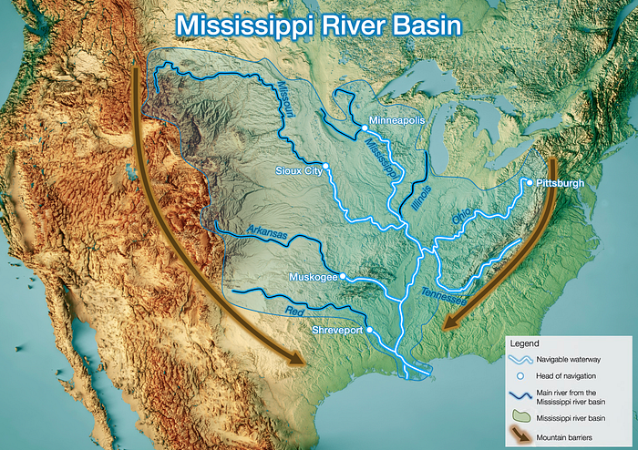
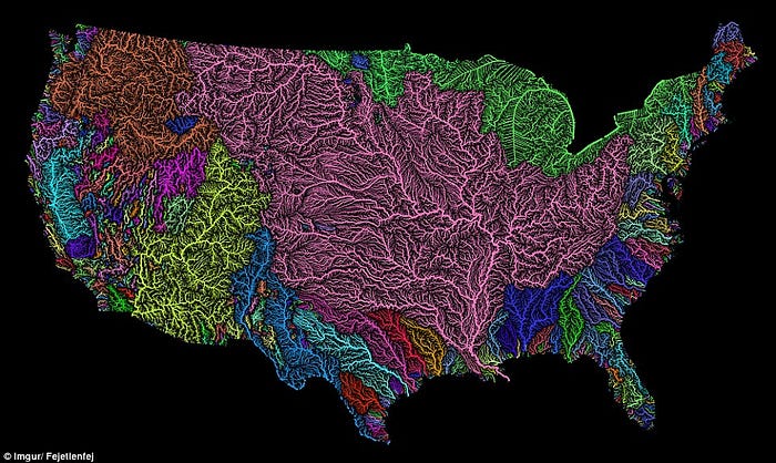
The Mississippi Basin is the 4th largest drainage basin in the world and occupies 40% of the contiguous 48 US states, touching 32 of the US's 50 states. 11 US states directly take their name from it.
And it's caused by the incredible funnel effect caused by the Sierra Nevada / Rockies to the west and the Appalachians to the east.
How is this so useful? Because it's unbelievably fertile.
2. Farmland
This whole region is naturally well irrigated.
It's also super flat.
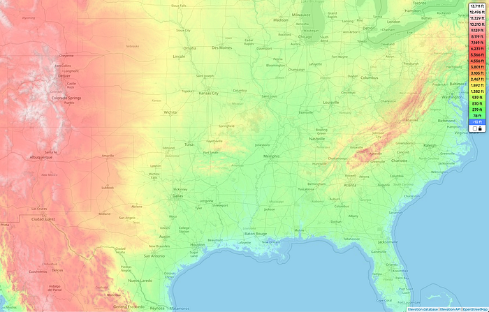
This makes the Mississippi Basin the world's largest contiguous piece of farmland.
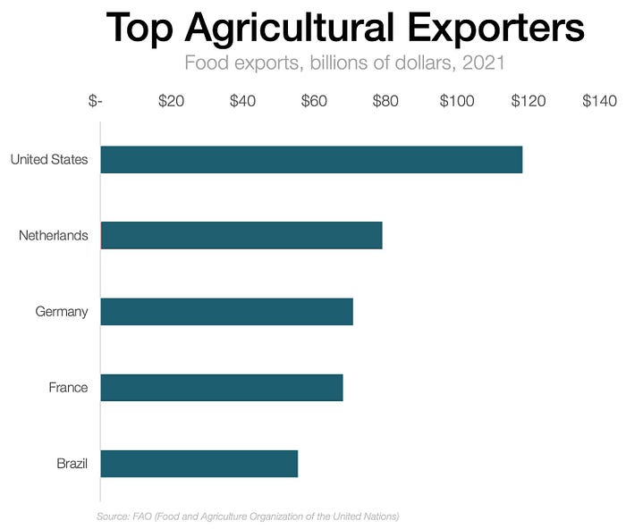
Because of this, the US is the 3rd biggest producer of food worldwide, and the biggest exporter.
3. Mississippi Trade
This huge, flat river basin also has many navigable rivers. Together, they give the US more navigable internal waterways than the rest of the world combined. Here's one awe-inspiring fact: The head of navigation of the Mississippi (the farthest you can navigate upstream) is Minneapolis, which is a brutal 3,000 km (~1,800 mi) inland.
This is extremely useful because, as many of you already know, moving goods over water is 10–30x cheaper than overland.
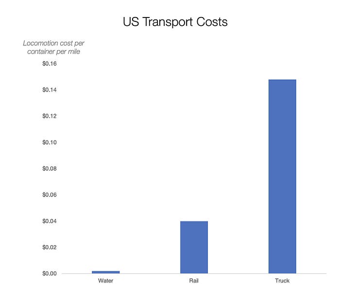
As a reminder, halving transportation costs can increase trade by 16x!
Cheap transportation is why Rome, Spain, Portugal, the Netherlands, Japan, Germany, France, the UK, and the US got rich and created empires. Conversely, even in modern times, it is common for Russian and Kazakh crops to occasionally rot before they can reach market due to high transportation costs: long, unreliable connections and poor infrastructure because it's so expensive. It is not unusual for a significant portion of the Russian grain crop — millions of hectares in some years — to remain unharvested!
Most countries require massive investments in transportation networks to reach their full potential, but not the US's Greater Mississippi Basin. The vast majority of
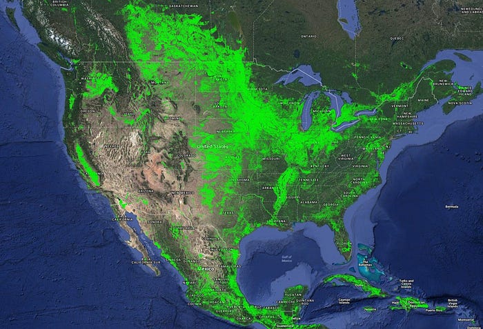
prime agricultural lands are within 200 km of a stretch of navigable river. Road and rail are still used for collection, but nearly omnipresent river ports allow for the entirety of the basin's farmers to easily and cheaply ship their products to markets, not just in North America but all over the world.
Rivers are more useful than coastlines because:
- Navigable rivers service twice the land area of a coastline (rivers have two banks, coasts only one).
- Rivers are not subject to tidal forces, greatly easing the construction and maintenance of supporting infrastructure.
- Storm surges often accompany oceanic storms, forcing the evacuation of oceanic ports.
In summary, the Mississippi Basin has the best farmland in the world and the best way to transport crops, making the region fabulously rich.
4. Political Integration
Because the center of Europe is mountainous, it has many rivers flowing in different directions. Each river system created different societies that became the individual nationalities we know today.

Now look at the rivers in the US, and compare the Mississippi with the Atlantic Seaboard to the east.
Because the Appalachians Mountains are parallel to the US Atlantic Coast, rivers flow from the mountains to the coast and seldom cross each other. Each river developed its own economy, its own hinterland, its own port city on the coast. This was one of the reasons why there were 13 pretty independent colonies on the US East Coast, and without this division, the US Civil War would have been much less likely.
Meanwhile, the Mississippi is one big system, which makes political integration easy. All of the peoples of the basin are part of the same economic system, ensuring constant contact and common interests. Regional proclivities obviously still arise, but this is not Northern Europe.
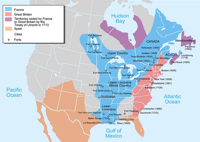
We could see this as early as the 1700s, when the entire basin was claimed by Spain and France.
Incredibly, despite the Mississippi's vast length of over 3,000 km, it barely slopes 200 m. This makes its water slow — and hence navigable. But it also gives it another boon: It's navigable until just a few miles from the Great Lakes!
5. The Great Lakes
The US has the largest freshwater lake system in the world, the Great Lakes. Its de facto capital, Chicago, became so huge because it's the hinge between the Mississippi and the Great Lakes.
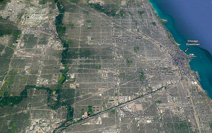
This means the huge Mississippi Basin and the Great Lakes are seamlessly integrated through cheap water transportation — which became even better after the canals were built in the area — and both have access to the ocean. Dozens of major inland US cities like Milwaukee, Detroit, or Cleveland are virtual seaports! US goods again get a permanent advantage.
Unlike the Greater Mississippi Basin, the Great Lakes are not naturally navigable due to winter freezes and obstacles such as Niagara Falls. However, over the past 200 years, extensive hydrological engineering has been completed — mostly by Canada — to allow for full navigation of the lakes. Since 1960, the Great Lakes have provided a secondary water transport system that has opened up even more lands for productive use and provided even greater capacity for North American capital generation. The benefits of this system are reaped mainly by the warmer lands of the United States rather than the colder Canada, but since the Great Lakes constitute Canada's only maritime transport option for reaching the ocean, it still financed it.
But that's not all!
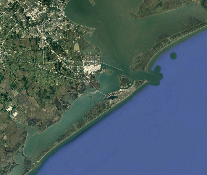
6. The Intracoastal Highways
Ships can travel from Boston to Mexico barely touching open seas, instead protected by chains of islands that cover nearly all of the US' Atlantic coast.
This is what it looks like when you zoom into one of these intracoastal waterways:
The rivers of the Mississippi basin and the intracoastal waterways amount to more internal navigable waterways than in the rest of the world combined! What?!
In addition to serving as a sort of oceanic river, the island chain's proximity to the Mississippi Delta is like an extension of Mississippi shipping, supporting political and economic unification of the Mississippi Basin with the eastern coastal plain.
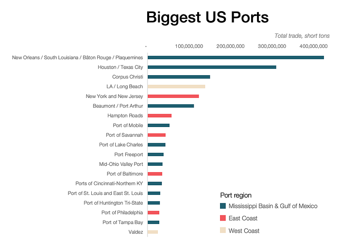
This is why most of the US's biggest ports are in the Mississippi Basin or on the Gulf of Mexico. But not all.
7. Natural Coastal Ports
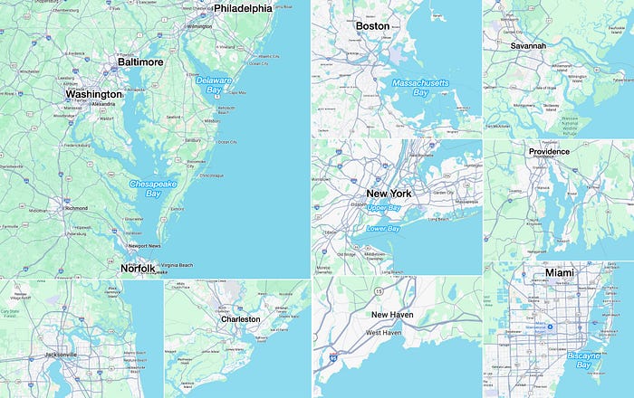
The East Coast also has many huge natural ports, thanks to the rivers flowing from the Appalachians, which form big estuaries ideal for protecting ports from tides and storms:
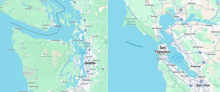
The same is true on the West Coast, with the San Francisco Bay and Seattle's Puget Sound:
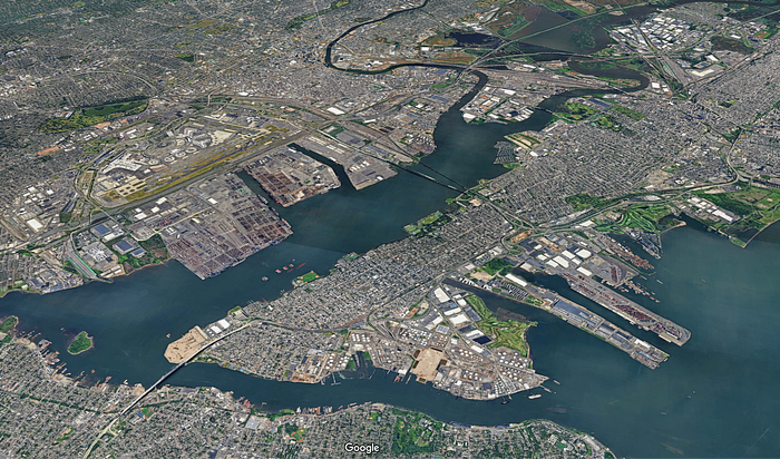
These ports have allowed heavy trade with limited investment in port infrastructure, and hence cheap transportation costs. A great way to get rich!
So the Mississippi Basin is the continent's core, and whoever controls it will dominate the East Coast and Great Lakes, easily producing lots of food and other goods, which it could trade anywhere in the world cheaply and fast, making it a world superpower.
But in the 20th and 21st centuries, a superpower also needs power. It needs energy to dominate. Luckily, the US has plenty.
8. Energy
The US is the #1 producer of both oil and gas in the world!
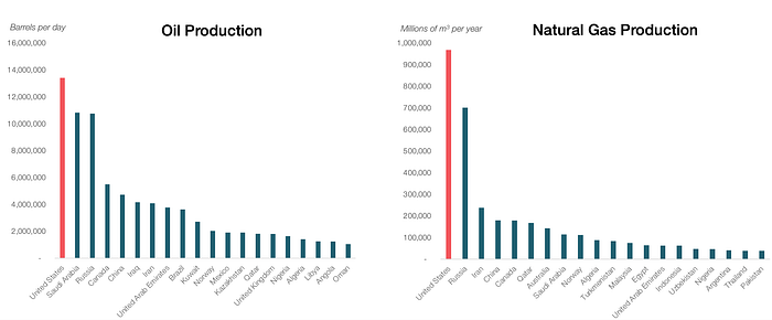
This production comes from the exploitation of huge oil and gas resources: The US has the 4th largest number of gas reserves in the world and the 9th largest of oil.
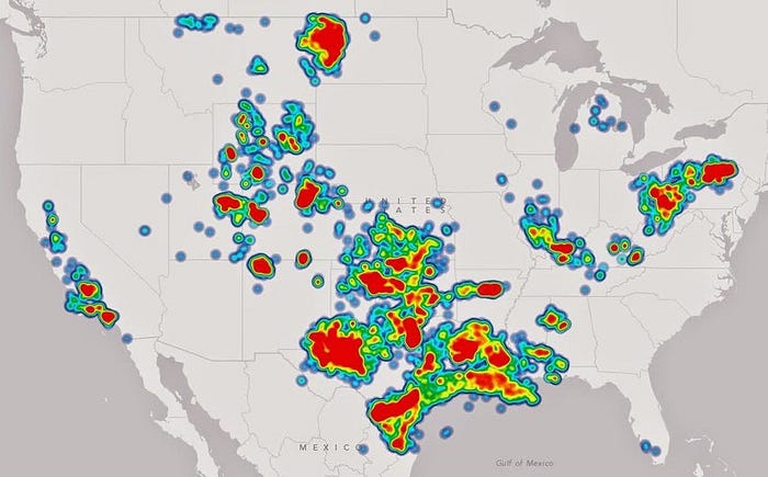
And how come the US has such incredible hydrocarbon resources?
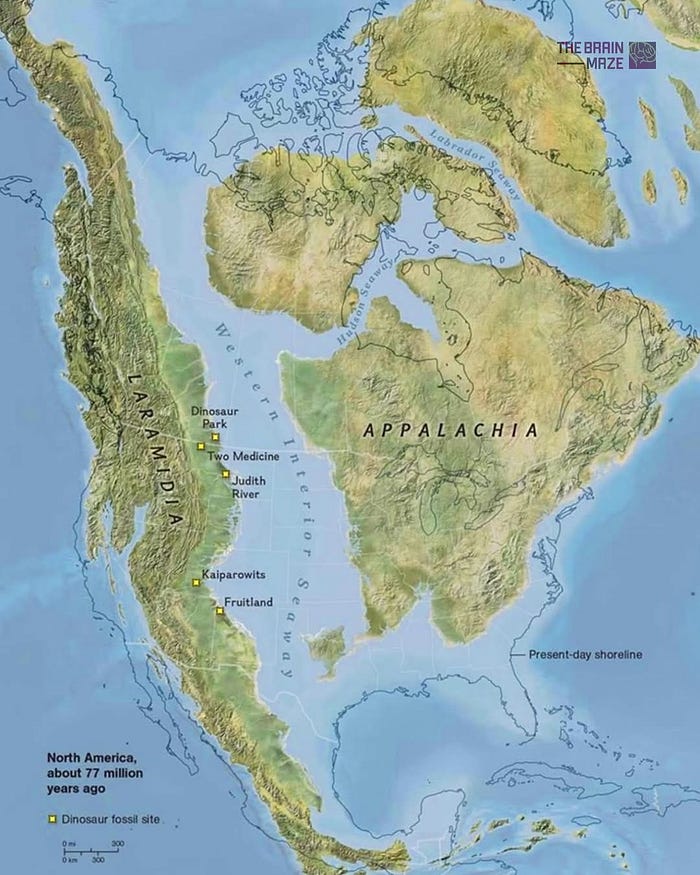
Because it used to have a shallow inland sea! Such seas are ideal for breeding life, as nutrients can't fall too deep and thereby remain accessible to sealife. Their corpses eventually do fall, pile up, and become oil and gas a few million years later.
With perfect farms and inland navigable waterways and ports and fuel reserves, the US geography is ideally positioned to produce wealth. Luckily, it's also ideally positioned to defend itself: The US is an impregnable fortress.
The Impregnability of US Defenses
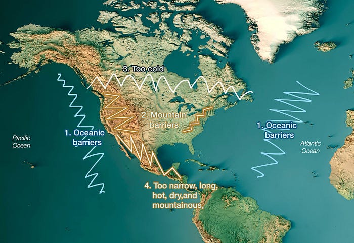
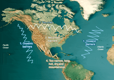
9. Oceanic Barriers
The US sits between the world's two largest oceans. This makes any invasion by sea virtually impossible. Germany couldn't invade Britain across 15 mi of the English Channel during WW2; the Pacific and Atlantic Oceans are massive >2,000 mile barriers.
Does history disprove this?
- Japan attacked Pearl Harbor, in Hawaii.
- The UK's navy led two wars to US soil, the War of Independence and the War of 1812.
But Japan attacked Pearl Harbor because it couldn't reach farther, and it was only an aerial attack. It would have been impossible to put boots on the ground across such a long distance. Even the US has had a hard time in operations like the invasions of Iraq and Afghanistan, given these distances.
The same is true on the Atlantic side. The UK did carry out two attacks on the US, including blockades that starved the local economy. But at the time, the UK was the most powerful country in the world, with the strongest navy, yet it still couldn't beat a very weak and fledgling US. Not only that, but the US was limited to the East Coast, and most battles stayed close to that coast.
Why?
10. Mountain Barriers

To the east, the Appalachians are not too high (~max 6,700 ft / 2000 m), and yet they were enough to stop the Brits. A zoom-in shows why:
This means the East Coast is exposed to seaborne attacks, and that's one of the big reasons why the US expanded westward: To utilize the buffer of the coast and Appalachians against any naval attack.
To the west, the enormous Sierra Nevada and Rockies are both high and dry; anyone getting a foothold on the West Coast would still never be able to control them, and would have been repelled soon after.
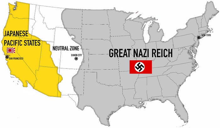
This is why a scenario like in The Man in the High Castle would have been impossible.
11. Ice Barrier
The US has 8x more population than Canada because most of Canada is an ice desert. On top of that, its soil is very bad because of the Canadian Shield, which means its agricultural potential is limited, and with that, its independence. The result of all this is that 80% of its population is spread across three regions, all of which are disconnected from each other but highly connected to the much more economically fruitful US.
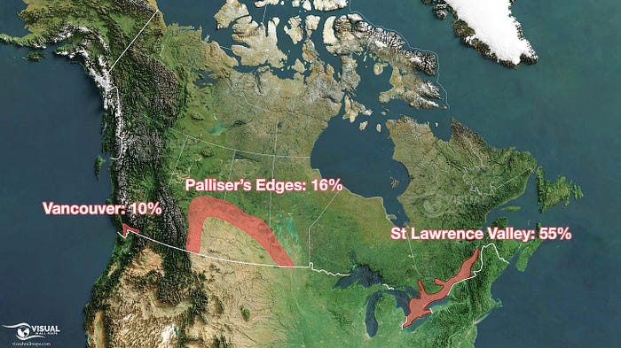
Which, in turn, makes Canada exceptionally exposed to the US and makes hostility from Canada toward the US impossible.
Despite this, most of the border between the US and Canada is made of lakes and forests: hard to pass, easy to defend. The US is very safe from Canada.
12. Desert Mountain Barrier
Mexico is not Canada. It has a population of 130M people, it was as rich per capita as the US before the Industrial Revolution, and it used to be a mere 150 km away from the US's keystone: New Orleans. The country that controls New Orleans controls the Mississippi, and with it the heartland of the US.
Not only that: New Orleans is swampy — which makes it hard for maintaining an army — whereas neighboring Texas is made up of forested plains and hills — ideal for hosting a foreign army.
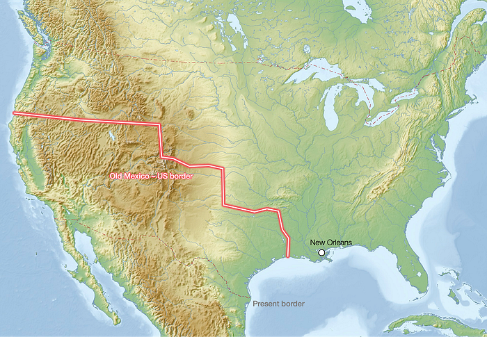
Some US statesmen probably thought: "If the border were only a bit farther south, it would be very convenient for us: It would be narrower, even more desertic, and farther from the key port of New Orleans".
And that's a major reason why the US supported English-speaking people settling in Texas, before then fostering a revolution there against Mexico, and finally incorporating Texas as a US state.
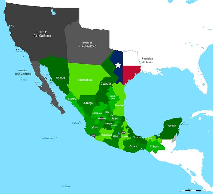
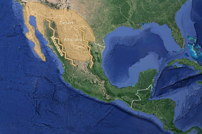
The US–Mexico War didn't just bring Texas to the union, but it snatched 55% of Mexico's size, including land reaching to the Pacific, and creating an even greater buffer with its southern neighbor. As we saw in the series about Mexico, that country is now neutralized as a potential threat:
What is now Mexico lacks even a single navigable river of any size. Its agricultural zones are disconnected and it boasts few good natural ports. Mexico's north is too dry while its south is too wet — and both are too mountainous — to support major population centers or robust agricultural activities. Additionally, the terrain is just rugged enough — making transport just expensive enough — to make it difficult for the central government to enforce its writ. The result is the near lawlessness of the cartel lands in the north and the irregular spasms of secessionist activity in the south. — Stratfor
13. Global Buffers
The US didn't stop its defense at its borders. At the end of WW2, it deftly expanded it to a global magnitude:
- With the Monroe Doctrine, it claimed that no colonial power could set foot in the Americas — and largely succeeded.
- With NATO, it created a buffer to its east against Russia.
- With its alliances with Japan and South Korea, and the purchase of Alaska, it made a buffer to its west against Russia.
- This buffer expands southward to contain China, by including Taiwan, the Philippines, Australia, and New Zealand.
These countries are not just allies. They have been modeled on the US system, so even under a stupidly antagonistic regime like Trump's, they will remain firmly aligned with the US.
Takeaways
The US has:
- Some of the best farmland in the world
- The best naturally navigable waterways in the world
- Amazing natural ports
- All of these connect US regions to each other, uniting them politically
- It also has some of the best oil and gas resources to fuel its economy
- And it has several layers of defense to protect all this wealth, starting with the two largest oceans, one on each side
- After the oceans, it has two insurmountable mountain barriers that further defend its heartland
- Its neighbor to the north is sparsely populated because it's too cold and infertile
- Its neighbor to the south is weaker and separated by a narrow mountainous desert
- The US has managed to extend its model to countries across the world, creating buffers that repel all the other natural superpowers, Russia, China, and India
In a world that sees China climbing, and witnesses how the US shoots itself in the foot with stupid policies like tariffs, it's easy to fear the US might be set aside as a have-been. But its geography makes it impossible: It will always be rich, and it will be impossible to physically threaten.
I would personally never bet against the US.